Kern-Kaweah and Kaweah Basins
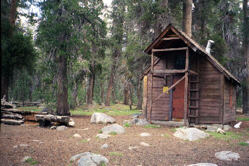
The snow survey cabin at Rowell Meadow where once there was an extensive cow camp.
Rowell Meadow
Kern-Kaweah and Kaweah Basins via Colby Pass, September, 2000.
September, 2000. Day 1
This trip started out with a minor disaster, and one after another more things kept happening. Still, it was one of the best and most memorable trips ever.
This trip was to begin near Big Meadows next to Kings Canyon, and area that was recently protected by the US Government to save it from the ravages of further logging and other abuses for this high, well used and beautiful area. It was not a moment too soon because loggers were logging right next to the park boundary in the hopes, I believe, of creating a buffer zone to discourage the area from becoming designated as a Wilderness Area. Fortunately, that ploy failed and though there has been heavy damage to some fragile areas, there is hope the area will recover. I remember walking one of the logging roads in the area some year's back and as I neared the Jenny Wilderness boundary I found a small swampy meadow the road circled that was complete ravaged by the logging activities. Some family of bears probably lost a prime forage site. Hopefully, the meadow will recover.
We left early and arrived at the Ranger Station past noon to pick up our permit, and soon after we were on the beautiful Big Meadow road heading for the Sunset Meadow trailhead. The road is paved until you get on the Sunset Meadow road, which is a dirt road. The road passes through a pack station with excessively high speed bumps, and though a carefully driven car can get to this trailhead, I was glad I was driving my high clearance 4 by 4 vehicle. At one point well beyond the pack station there is a rather deep rut crossing the road you have to look out for. Also keep a lookout on your right to see Sunset Meadow, for which this trailhead is named after.
At the trailhead there is ample parking for both cars and horse trailers. This trailhead is very popular with horse-packers with whom you have to share the trails in this region. One word of warning: the trailhead itself is not so obvious. You see the signs, the campsites and the outhouse at the end of the parking loop, and there is even a trail of sorts there, but that is NOT the trail to use. The actual trail is near the entrance/exit of the parking loop and you have to look for it. Don't be fooled.
After securing my vehicle and mounting up, we gleefully hit the trail for parts unknown (to us). Actually, I had been up this trail twice before, once on a trip to Seville Lake, and another time to Jenny Lake. Also, I had been through the Sugarloaf Valley on the Deadman Canyon loop trip some year's back, and I was actually looking forward to the return to the area. For my partner, this was his first visit to this area.
Like much of the past strange wet summer, the weather was hot and muggy, and the heat of hiking was somewhat relieved by the occasional cloud.
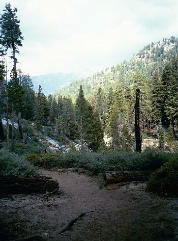
From the trailhead, the trail makes a right hook then begins to take a long traverse up the steep slope of Mt. Maddox. At first in forest, the trail eventually breaks out into the open on broken and blasted granite. Minor views open up of a fairly impressive exfoliating granite dome across a gulf with a stream draining Rowell Meadow at the bottom. After a long moderate climb the trail turns a corner and re-enters the woods and eventually meets the stream on fairly level pathway. The trail climbs again and seems to wander aimlessly about before leveling out and arrowing towards Rowell Meadow. When the junction to Jo Pass and Jenny Lake was reached, we turned left for Rowell Meadow where we found the snow survey cabin and a rest break.
Beyond Commanche Meadow the trail descends to the Shugarloaf Valley floor and occasionally there is a view to be had.
The meadow is large, and over it can be seen Profile View in the distance. The cabin construction is of some interest to the idly curious, and there is a camp in the area. It was here the first of the minor disasters occurred. I was eating a soft snack when, much to my exasperated annoyance, one of my tooth crowns came off. I stuck it back on and was able to use it for three days until I swallowed it. Well, the hike must go on, and I did.
From this point one has two choices of routes to Sugarloaf Valley: the trail to Seville Lake, or the trail to the left that looks like the direct route. I had already done the Seville route, but the map seemed to say the left route was the shorter one. I was wrong. If I were to do this again, I would choose the Seville route. Even though it is a mile more on the map, the Seville route is much more direct and straightforward (even if it does not look it on the map), and the hiking is much easier. But we mounted up and took the left route.
Unfortunately, the way we went is also most used by horse-packers, so it was soft, dusty and dirty in most places. Fortunately yet another freak rainstorm had recently raged through the area and kept the dust down to a minimum. Also, this route tended to roller coaster up and down, and when it was not doing that, it was madly switchbacking back and forth. Occasionally there was a glimpse of a view through the trees, but that was it. Some of the trees were impressively large and made for a nice dense canopy overhead, but mostly the trail was very uninteresting. We reached Commanche Meadow, and the camp, bearbox, and trail junction there. You actually have to search for the meadow and there is a short spur trail leading to it.